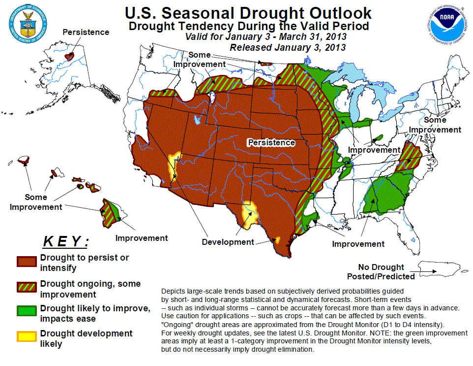
Forecast confidence for eastern Texas
and western Louisiana is moderate to high:
- Widespread precipitation during the latter half of December boosted moisture and improved drought conditions across far eastern Texas and western Louisiana.
- Additional precipitation is expected during the week 1 period, although amounts are expected to remain well below an inch. The CPC 8 to 14 day outlook tilts the odds slightly in favor of above median rainfall, and the 12Z January 2 run of the GFS suggests the possibility of higher accumulations during week 2.The CPC January updated outlook and the CFS version 2 model both indicate enhanced chances of above median precipitation for eastern Texas and Louisiana.
- Based on this guidance and the currently improving drought situation, further improvements are expected across extreme eastern Texas. Despite current light rainfall, drought persistence is more likely across southern Texas, where deficits are much longer term.
Forecast confidence for the Southeast is moderate to high:
- During the previous two weeks, widespread heavy rainfall overspread the long term drought areas of the Southeastern U.S., with more than double the normal rainfall amounts falling across central Alabama, northern Georgia, and the western Carolinas during a climatologically rainy period of the year. These rains boosted streamflows and brought some drought relief, particularly to areas near the Georgia and Alabama border.
- During the upcoming week, rainfall is expected to fall mainly to the south of the core drought areas, but the CPC week 2 outlook maintains enhanced odds of above median rainfall for the Southeast. The updated January outlook also tilts the odds towards above median rainfall, while the seasonal forecast maintains equal chances.
-
Drought improvement is likely for much of the Southeast based on the latest runs of the CFS version 2 climate model predict significant. Positive precipitation anomalies for the southeastern U.S. through February. Based on the November Palmer Hydrological Drought Indices for the Southeast and climatology, the NCDC indicates that for much of the Southeast, near to slightly below average precipitation during the December through March period is sufficient to ameliorate extant drought conditions.
Forecast confidence for the Plains is moderate.
- A potent winter storm brought significant snowfall to western Kansas and most of Nebraska during the second half of December, while below average precipitation was observed elsewhere across the Plains states.
- Streams have frozen for the winter across the Dakotas and eastern Montana under a substantial snow pack. The December through March period is a climatologically dry time of year for the Plains. Little to no precipitation is expected during the upcoming week. The CPC 8 to 14 day outlook tilts the odds towards below median precipitation across the southern High Plains, and towards above median precipitation across the northern Plains.
- The CPC January outlook maintains the enhanced odds of above median precipitation for the northern Plains, while the seasonal outlook keeps equal chances. Based on the dry climatology, drought persistence is expected for most of the Plains. Additional development across the Texas high plains is possible, while some improvement may be seen across the northern tier, with the greatest benefits occurring during the spring melt.
Forecast confidence for the southern Atlantic states is low.
- Drought conditions persisted or intensified across central North Carolina and Virginia despite near to above average precipitation during the previous two week period, as the heaviest rain and snowfall fell both to the north and south of the region.
- The 28 day streamflow averages remained below to much below normal, and the 60 to 90 day SPI values remained substantially negative. Little additional precipitation is expected during the upcoming week, although the CPC 8 to 14 day outlook predicts enhanced probabilities of above median precipitation.
- The CPC monthly and seasonal outlooks both maintain equal chances of above, near or below median precipitation, and the CFS version 2 model predicts no substantial precipitation anomalies. Climatologically, the January through March period is a drier time of year for this region. Based on these considerations, some improvement of drought is indicated.
Forecast confidence for the West is moderate to high.
- Well above average rainfall continued across much of central and northern California and parts of Nevada during the previous two weeks, while drier conditions prevailed across the Southwest and much of the Pacific Northwest. The CFS version 2 forecasts have consistently predicted strongly negative precipitation anomalies across portions of the western U.S. during the winter months, but these forecasts failed to verify as repeated storm systems pushed ashore in California and Oregon throughout the late autumn and early winter.
- The phase of the PNA became positive during the last week of December, however, bringing an end to the story pattern. During the upcoming week, light precipitation is expected along the Pacific coastal areas, while dry conditions are forecast for the Sierra Nevadas. The CPC 8 to 14 day, January monthly, and seasonal outlooks all predict enhanced chances of below median precipitation for California and the Four Corners states during the outlook period.
- February is the wettest month of the year climatologically for the Central Valley of California, so significant negative precipitation anomalies during this period have a high impact on drought conditions in the spring. Based on the dry guidance, drought persistence is expected. Additional development areas have not been included in this outlook due to the incipient wetness in the region, but may be required in subsequent outlooks if the dry forecasts verify.


Post a comment
Report Abusive Comment