.webp?t=1654194174&width=638)
By: Mehmet Ozturk and Anna Cates
Two ongoing studies are measuring how much soil is being blown across different fields, and how much nutrients lost with wind erosion might cost farmers.
Wind Erosion
Sometimes you can see the soil leave your field, washing into the ditches with a spring rain or blowing across the roads and getting through the windows of houses. Other times it’s more subtle and slow. Most hilly fields have knobs with lighter soil due to long-term wind, water, and tillage erosion. Aside from on-farm nutrient losses, wind-eroded sediment can cause traffic accidents, increase respiratory problems, and change how water moves on the landscape. When snowpacks mix with dust, they absorb more sunlight and melt earlier. Technically, wind erosion is defined as the transportation of soil particles from one location to another, and it easily occurs where soil is bare, loose, and dry. It is difficult to measure where soil comes from and where it’s deposited. Many different factors, such as soil moisture, organic matter, aggregate stability, topography, surface cover, and so on cause wind erosion to behave erratically from one field to the next, and even across a single field.
Measurement Methods
Dust samplers or traps such as Big Spring Number Eight (BSNE) and Modified Wilson and Cooke (WMAC) catch sediment blown by wind, with masts placed at different heights to get a sense of the vertical distribution of windblown sediment. Mesh mats placed on the ground estimate sediment movement by wind or water across the soil surface. Both mats and dust samplers measure movement of sediment in a given environment, but can’t confirm loss of sediment. Edge of field monitoring can capture runoff which actually leaves the farm field (although some of it could have been displaced from other locations).Sampling in ditches;also provides an estimate of loss, but can’t confirm the origin of sediment.
Two Ongoing Research Projects
Project One: In 2021, we began looking at spring sediment movement in Murray County in southwest Minnesota. A corn/soybean farmer received a Minnesota Department of Agriculture grant to evaluate different tillage methods for yield, economics, and erosion. We used the erosion mats to measure sediment moving along the surface of the field between corn planting and the first herbicide application. The treatments (strip-till vs field cultivation) were applied in 60-foot replicated strips, and five mats were used in each of three locations across the field. Our first year of data showed more sediment was moving in the field-cultivated strips, with significant levels of nutrients in the moving sediment.
|
|
Strip-till | Field-cultivated |
|---|---|---|
| Sediment movement (lbs/acre) | 449 (±328) | 1074 (±1148) |
| Nitrate (mg/kg)* | 51.59 | 51.59 |
| Phosphorus (mg/kg)* | 36.2 | 36.2 |
| Potassium (mg/kg)* | 182.4 | 182.4 |
*Note that samples were too small to estimate nutrient content separately for each treatment. Phosphorus was measured using the Bray method.
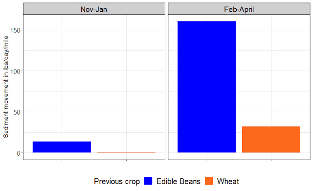
Project Two: Over the 2020-2021 winter, wind-blown sediment was collected in small boxes (BSNE samplers) mounted at one foot above the ground. We placed two collectors in each of four 40-acre fields in Walsh County in northeast North Dakota, a conservation demonstration funded by General Mills. The fields differed in tillage treatments (tilled vs no-till) and crop rotations (following edible bean vs following wheat). In this case, tillage had no effect on the amount of sediment moving, but the previous crop had a huge effect. Edible bean leaves minimal residue on the ground, and much more sediment moved in those fields. If you extrapolate the measured sediment along a one-mile section of road, one foot off the ground, we estimate that up to 160 pounds of sediment per day per mile could move in these systems. Again, the sediment blowing is high in nutrients and organic matter. If all that nitrogen (N), phosphorus (P), and potassium (K) left the field between November and April, that sediment was worth up to $40 (December 2021 prices: $0.951/lb N, $0.918/lb P, $0.665/lb K).
Overall, these preliminary data indicates that management makes a difference: leaving residue on a field or planting cover crops, and less aggressive tillage, can slow down soil movement, which keeps more nutrients in place for the following crop.
One thing we know from edge-of-field monitoring, by the Discovery Farms Programs in Minnesota and Wisconsin and the Root River Field to Stream Partnership in southeast Minnesota, is that erosion is flashy— a few events can have a big impact on total soil movement. So, these preliminary data shouldn’t be taken as average statewide values. We’ll continue collecting data at these sites, and add more robust wind erosion data on sugarbeet fields, which are particularly vulnerable to winter erosion due to low residue cover and intensive tillage after beet harvest. We’ll use the BSNE masts to measure sediment movement at different heights, comparing fields with a cover crop seeded after beet harvest to those with no cover crop. Cover crops have just a short time to grow after beet harvest, so we’ll see if they provide enough residue cover to slow loss of sediment and nutrients.