A devastating line of thunderstorms that began in southwestern Nebraska the evening of July 10 rapidly moved east-northeast into northwestern Iowa in the early morning hours of July 11.
The line weakened slightly before rapidly gaining strength over central Iowa, creating a fast moving bow echo that moved over 500 miles in less than 12 hours.

|
Peak gusts were estimated at 110-130 mph in a 5-by-30 mile area that extended from Des Moines and Ames east through Marshalltown, Iowa.
Along the entire 150-mile line of thunderstorms there were confirmed wind speed gusts of 60 to 80 mph from Iowa east through northern Illinois, southern Wisconsin, southern Michigan, northern Indiana, northern Ohio, and southern Ontario.
Damage assessments are ongoing and it will likely be several weeks before the extent of yield reductions is known. Green snap was a certainty, but much of the corn impacted by this event appears to have been laid flat and may actually recover somewhat as the tops begin bending upward (gooseneck). Several million acres likely received some wind damage, with the worst damage occurring in areas that consistently have produced 200+ bu/ac yields.
|
For more graphics |
What is more uncertain is how the impending heat wave will impact a crop that is beginning to enter the critical pollination period. If there is enough goosenecking, adequate pollination can occur. If pollination is not deterred by heat stress, harvest will likely be slow going in these tangled fields and ear drop may be substantial.
This fast moving bow echo is called a “Derecho” in meteorological terms. Because of its rapid speed, precipitation totals were generally less than an inch, with many areas of eastern Iowa through Ohio receiving less than 0.50 inch. This event happened over an area that has turned exceptionally dry during the past three weeks and did little to improve crop moisture prospects. (See the July 8 CW article.)
Heat Wave to Hit at Pollination
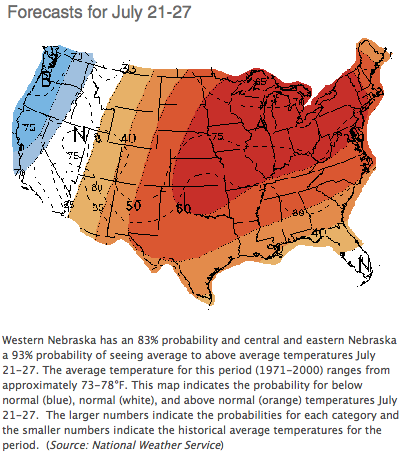
Much of the Corn Belt from Nebraska through Illinois is rapidly approaching pollination and there is now strong agreement among weather models that there will be 7-10 days of high temperatures ranging from the mid 90s to the low 100s. Dry areas east of Nebraska are likely to suffer from pollination issues, particularly where moisture stress has already been observed.
Although recent precipitation has benefitted Nebraska’s corn crop, the crop could rapidly deteriorate due to the impending heat and lack of significant moisture indicated by the weather models for July 15-22. Less than three weeks ago eastern Kansas had the potential to produce above normal corn yield. Now intense heat has led to significant pollination problems, even on irrigated acreage.
The most recent models indicate that high temperatures across the southern third of Nebraska will range from 95°F to 103°F from July 15-22, with northern areas averaging five degrees cooler. A brief cool down into the 80s is indicated for July 23-27 before the heat returns. Models also keep moisture well north of the state, with the exception of the Panhandle where an isolated thunderstorm can’t be ruled out.


Post a comment
Report Abusive Comment